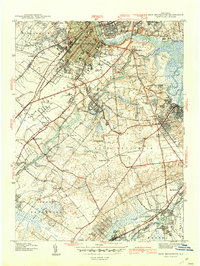
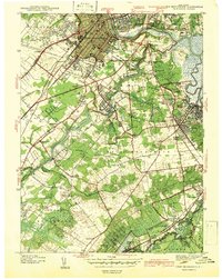
1942 Map of New Brunswick
USGS Topo · Published 1942About this map
The Raritan River and the historic D & R Canal define the northern landscape of this 1939 survey, framing the dense urban grid of New Brunswick and Highland Park. This period of development highlights the significant footprint of Rutgers Univ and the New Jersey Experimentation Agriculture Grounds, reflecting the area's importance as an educational and scientific hub. The infrastructure of the early 20th century is evident in the crossings of the Pennsylvania Railroad and the Lehigh Valley lines, which supported the industrial reach of South River and Spotswood. Southward, the map transitions into a network of smaller crossroads and rural settlements such as Berdines Cor, Dunhams Cor, and Paulas Cor. The presence of several local institutions, including Georges Road Ch and the Dejeulyehuor Cemetery, offers specific points of interest for genealogists tracing family roots in Middlesex and Somerset counties.
Find a feature on this map
76 named features on this map. Tap any name to fly to it.
Don’t see what you’re looking for? This feature index may not catch every label — zoom into the map to look around manually.
Map Details
Editions of this 1942 New Brunswick Map
2 editions found
Other maps of this area

1888 · Plainfield
USGS Topo · 1:62,500

1888 · New Brunswick
USGS Topo · 1:62,500

1888 · Princeton
USGS Topo · 1:62,500

1891 · Somerville
USGS Topo · 1:62,500

1893 · New Brunswick
USGS Topo · 1:62,500

1893 · Plainfield
USGS Topo · 1:62,500

1893 · Somerville
USGS Topo · 1:62,500

1894 · Princeton
USGS Topo · 1:62,500

1898 · Plainfield
USGS Topo · 1:62,500

1898 · Somerville
USGS Topo · 1:62,500