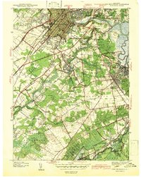
1942 Map of New Brunswick
USGS Topo · Published 1942About this map
New Brunswick and Highland Park are separated by the winding path of the Raritan River in this detailed 1939 survey. The map documents a diverse landscape of university expansion at Rutgers Univ, industrial development, and rural crossroads. The Pennsylvania Railroad and the historic Lincoln Highway corridor cut through the landscape, driving the growth of surrounding settlements like Milltown and Voorhees.
Find a feature on this map
75 named features on this map. Tap any name to fly to it.
Don’t see what you’re looking for? This feature index may not catch every label — zoom into the map to look around manually.
Map Details
Editions of this 1942 New Brunswick Map
2 editions found
Other maps of this area

1888 · Plainfield
USGS Topo · 1:62,500

1888 · New Brunswick
USGS Topo · 1:62,500

1888 · Princeton
USGS Topo · 1:62,500

1891 · Somerville
USGS Topo · 1:62,500

1893 · New Brunswick
USGS Topo · 1:62,500

1893 · Plainfield
USGS Topo · 1:62,500

1893 · Somerville
USGS Topo · 1:62,500

1894 · Princeton
USGS Topo · 1:62,500

1898 · Plainfield
USGS Topo · 1:62,500

1898 · Somerville
USGS Topo · 1:62,500