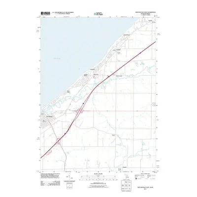
2011 Map of New Buffalo East
USGS Topo · Published 2011About this map
The Lake Michigan shoreline in Berrien County is defined by a dense series of beach-front communities and vacation settlements. From New Buffalo in the southwest up through Gordon Beach, Union Pier, Lakeside, and Harbert, the map illustrates how transportation infrastructure, specifically the highway and rail corridor, parallels the coast to support these coastal enclaves. While the shoreline is heavily developed with residential grids and landings like Skippers Landing, the interior transitions into a landscape shaped by the winding Galien River and its various tributaries, such as the South Branch Galien River and Squaw Creek. This inland area maintains its rural character, anchored by sites of local heritage including Basswood Cemetery and Heckman Memorial Cemetery near the settlement of Hesston. The distribution of post offices across these small communities highlights the historical independence of each settlement before modern consolidation.
Find a feature on this map
25 named features on this map. Tap any name to fly to it.
Don’t see what you’re looking for? This feature index may not catch every label — zoom into the map to look around manually.
Map Details
Editions of this 2011 New Buffalo East Map
This is the sole edition of this map. No revisions or reprints were ever made.
Other maps of this area

1930 · Three Oaks
USGS Topo · 1:62,500

1944 · Three Oaks
USGS Topo · 1:62,500

1953 · Chicago
USGS Topo · 1:250,000

1957 · Chicago
USGS Topo · 1:250,000

1958 · Michigan City East
USGS Topo · 1:24,000

1958 · Springville
USGS Topo · 1:24,000

1958 · New Carlisle
USGS Topo · 1:24,000
1969 · Michigan City East
USGS Topo · 1:24,000
1970 · New Buffalo West
USGS Topo · 1:24,000
1970 · New Buffalo East
USGS Topo · 1:24,000