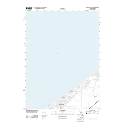
2011 Map of New Buffalo West
USGS Topo · Published 2011About this map
Lake Michigan defines the expansive western horizon of this coastal survey, where the Michigan and Indiana state lines meet along the southern shore. The shoreline is characterized by a dense string of residential lakefront communities, including New Buffalo, Grand Beach, and Michiana, which transition into Michiana Shores and Duneland Beach as the coast moves southwest. This layout reflects the area's twentieth-century development as a premier summer retreat and residential corridor, where leisure is central to the landscape. Inland, the map reveals the spatial footprint of the Grand Beach Golf Course and Whittaker Woods Golf Course, alongside the subtle drainage of White Ditch. These features highlight how the natural dunes and coastal marshes were adapted for recreation and community growth at the start of the 21st century.
Find a feature on this map
9 named features on this map. Tap any name to fly to it.
Don’t see what you’re looking for? This feature index may not catch every label — zoom into the map to look around manually.
Map Details
Editions of this 2011 New Buffalo West Map
This is the sole edition of this map. No revisions or reprints were ever made.
Other maps of this area

1930 · Three Oaks
USGS Topo · 1:62,500

1944 · Three Oaks
USGS Topo · 1:62,500

1953 · Michigan City West
USGS Topo · 1:24,000

1953 · Chicago
USGS Topo · 1:250,000

1957 · Chicago
USGS Topo · 1:250,000

1958 · Michigan City East
USGS Topo · 1:24,000

1958 · Springville
USGS Topo · 1:24,000
1962 · Michigan City West
USGS Topo · 1:24,000
1969 · Michigan City West
USGS Topo · 1:24,000
1969 · Michigan City East
USGS Topo · 1:24,000