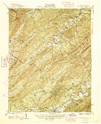
1947 Map of New Castle
USGS Topo · Published 1947About this map
Newcastle serves as a focal point in this 1947 study of the mountainous borderland between Virginia and West Virginia. The landscape is defined by the heavy presence of the Chesapeake and Ohio RR, which winds through the valleys supporting timber and mineral extraction. To the east, the Fenwick Mine (Abandoned) stands as a reminder of the area's industrial past, while the resort culture of the era is evident at Virginia Mineral Springs and Sweet Springs.
Find a feature on this map
71 named features on this map. Tap any name to fly to it.
Don’t see what you’re looking for? This feature index may not catch every label — zoom into the map to look around manually.
Map Details
Editions of this 1947 New Castle Map
2 editions found
Other maps of this area

1887 · Lewisburg
USGS Topo · 1:125,000

1890 · Roanoke
USGS Topo · 1:125,000

1890 · Christiansburg
USGS Topo · 1:125,000

1891 · Roanoke
USGS Topo · 1:125,000

1891 · Lewisburg
USGS Topo · 1:125,000

1894 · Natural Bridge
USGS Topo · 1:125,000

1913 · Eagle Rock
USGS Topo · 1:48,000

1915 · Eagle Rock
USGS Topo · 1:62,500

1921 · Callaghan
USGS Topo · 1:48,000

1921 · White Sulphur Springs
USGS Topo · 1:48,000