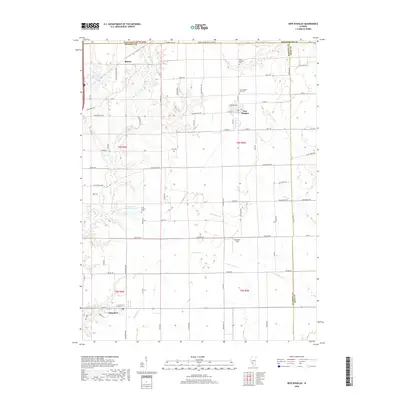
2018 Map of New Douglas
USGS Topo · Published 2018About this map
The agricultural landscape of eastern Madison County is anchored by the village of New Douglas and the town of Alhambra, showing a persistent pattern of rural Illinois settlement. This 2018 survey documents the intricate network of county roads and water systems, including the Staunton Coal Company Reservoir and the Big Four Reservoir in the northwest. Local history is preserved through numerous rural burial sites like Saint Ubaldus Cem and Harris Cem, while the hamlet of Binney remains a notable point in the northern reach of the quadrangle. The terrain is defined by the drainage of Silver Cr and its tributaries, such as Little Silver Cr and Sugar Fork, which carve subtle valleys through the surrounding farmland. These watercourses and reservoirs highlight the importance of water management in a region defined by both its coal mining heritage and its enduring agricultural economy.
Find a feature on this map
77 named features on this map. Tap any name to fly to it.
Don’t see what you’re looking for? This feature index may not catch every label — zoom into the map to look around manually.
Map Details
Editions of this 2018 New Douglas Map
This is the sole edition of this map. No revisions or reprints were ever made.
Other maps of this area

1912 · Gillespie
USGS Topo · 1:62,500

1915 · Gillespie
USGS Topo · 1:62,500

1915 · Mount Olive
USGS Topo · 1:62,500

1927 · Edwardsville
USGS Topo · 1:62,500

1932 · Edwardsville
USGS Topo · 1:62,500

1937 · New Douglas
USGS Topo · 1:48,000

1944 · New Douglas
USGS Topo · 1:62,500

1944 · Mount Olive
USGS Topo · 1:62,500
1954 · Marine
USGS Topo · 1:24,000

1954 · Worden
USGS Topo · 1:24,000