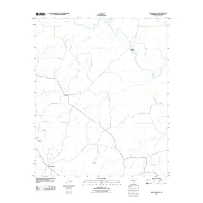
2011 Map of New Edinburg
USGS Topo · Published 2011About this map
New Edinburg and the winding course of the Saline River define this rural landscape in Cleveland County. The area is characterized by a dense network of creek systems including Cottonmouth Creek, Frazier Creek, and Hall Creek, which drain into the river basin. These waterways historically dictated the placement of early settlements and river crossings, such as Mount Elba and Bridges Bluff. The map preserves the locations of local landmarks and family-associated sites, including Marks Cemetery and Moseley Cemetery, which are essential for genealogical research in this part of Arkansas.
Find a feature on this map
49 named features on this map. Tap any name to fly to it.
Don’t see what you’re looking for? This feature index may not catch every label — zoom into the map to look around manually.
Map Details
Editions of this 2011 New Edinburg Map
This is the sole edition of this map. No revisions or reprints were ever made.
Other maps of this area

1953 · El Dorado
USGS Topo · 1:250,000

1957 · El Dorado
USGS Topo · 1:250,000

1958 · El Dorado
USGS Topo · 1:250,000

1960 · El Dorado
USGS Topo · 1:250,000

1966 · Kingsland
USGS Topo · 1:24,000
1970 · Fordyce NE
USGS Topo · 1:24,000
1970 · Calmer
USGS Topo · 1:24,000

1970 · New Edinburg
USGS Topo · 1:24,000

1970 · Herbine
USGS Topo · 1:24,000
1970 · Rison
USGS Topo · 1:24,000