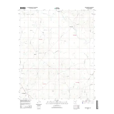
2014 Map of New Edinburg
USGS Topo · Published 2014About this map
New Edinburg and the nearby community of Hebron anchor the high ground in this 2014 survey of southern Cleveland County. The landscape is defined by the winding course of the Saline River, which flows past Mount Elba and Bridges Bluff in the north. This river valley was historically significant as a crossing point and early settlement corridor in Arkansas. The map details a network of rural roads such as Mt Elba Rd and Prairie Rd, connecting long-standing family landmarks and burial grounds. Genealogists will find several notable sites including Marks Cem near the western edge and Moseley Cem further south. Numerous creek systems, such as Cottonmouth Cr, Frazier Cr, and Hall Cr, drain the undulating timberlands, while the southern reaches are marked by the waters of L'Aigle Cr and Sixteen Cr.
Find a feature on this map
59 named features on this map. Tap any name to fly to it.
Don’t see what you’re looking for? This feature index may not catch every label — zoom into the map to look around manually.
Map Details
Editions of this 2014 New Edinburg Map
This is the sole edition of this map. No revisions or reprints were ever made.
Other maps of this area

1953 · El Dorado
USGS Topo · 1:250,000

1957 · El Dorado
USGS Topo · 1:250,000

1958 · El Dorado
USGS Topo · 1:250,000

1960 · El Dorado
USGS Topo · 1:250,000

1966 · Kingsland
USGS Topo · 1:24,000
1970 · Fordyce NE
USGS Topo · 1:24,000
1970 · Calmer
USGS Topo · 1:24,000

1970 · New Edinburg
USGS Topo · 1:24,000

1970 · Herbine
USGS Topo · 1:24,000
1970 · Rison
USGS Topo · 1:24,000