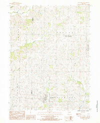
1984 Map of New Hampton
USGS Topo · Published 1985About this map
New Hampton and Martinsville serve as the primary hubs in this agricultural landscape straddling the Gentry Co Harrison Co line. In the early 1980s, the terrain was defined by a dense network of watercourses, including the West Fork Sampson Creek and Big Muddy Creek, which dictated the layout of rural roads and farmstead placements. The eastern portion of the map is dominated by the Grand Trace State Forest, providing a contrast to the surrounding gridded townships of Dallas, Howard, and White Oak. A lone Radio Tower stands as a notable vertical landmark near the center of the sheet, while family-named drainages like Ames Branch and Pony Branch reveal the long-standing local ties to the land. This provisional survey captures the region just before modern GIS mapping, reflecting the enduring rural character of Northwest Missouri.
Find a feature on this map
19 named features on this map. Tap any name to fly to it.
Don’t see what you’re looking for? This feature index may not catch every label — zoom into the map to look around manually.
Map Details
Editions of this 1984 New Hampton Map
This is the sole edition of this map. No revisions or reprints were ever made.
Other maps of this area

1925 · Pattonsburg
USGS Topo · 1:62,500

1925 · Darlington
USGS Topo · 1:62,500

1942 · Grant City
USGS Topo · 1:62,500

1943 · Grant City
USGS Topo · 1:62,500

1944 · Pattonsburg
USGS Topo · 1:62,500

1946 · Pattonsburg
USGS Topo · 1:48,000

1948 · Bethany
USGS Topo · 1:62,500

1948 · Pattonsburg
USGS Topo · 1:62,500

1950 · Darlington
USGS Topo · 1:62,500

1955 · Nebraska City
USGS Topo · 1:250,000