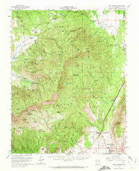
1957 Map of New Harmony
USGS Topo · Published 1972About this map
New Harmony sits at the northern edge of this high-desert landscape where the Dixie National Forest dominates the terrain. The map details a remote ranching and forest-service corridor in southwestern Utah, marked by established family spreads like Rencher Ranch, Gardner Ranch, and the Danish Ranch. Infrastructure for water management and resource protection is prominent, including the Browse Area Guard Station and several gaging stations along the Santa Clara River. High elevations like Signal Peak and Timber Mountain define the topography, while a network of springs—such as Ash Grove Spring and Columbine Spring—serves as the lifeblood for the isolated homesteads and recreation areas. The southern portion shows the transition toward Toquerville via the Anderson Junction, where the early paths of the Pintura Ditch and Hurricane Ditch trace the historical efforts to move water through this arid environment.
Find a feature on this map
80 named features on this map. Tap any name to fly to it.
Don’t see what you’re looking for? This feature index may not catch every label — zoom into the map to look around manually.
Map Details
Editions of this 1957 New Harmony Map
2 editions found

Other maps of this area

1885 · St. George
USGS Topo · 1:250,000

1891 · St. George
USGS Topo · 1:250,000

1950 · Kanarraville
USGS Topo · 1:24,000

1950 · Iron Mountain
USGS Topo · 1:62,500

1950 · Cedar City
USGS Topo · 1:62,500

1950 · Stoddard Mtn
USGS Topo · 1:24,000

1950 · Page Ranch
USGS Topo · 1:24,000

1951 · Kanarraville
USGS Topo · 1:24,000

1951 · Stoddard Mtn
USGS Topo · 1:24,000

1951 · Page Ranch
USGS Topo · 1:24,000