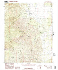
1986 Map of New Harmony
USGS Topo · Published 1987About this map
New Harmony sits at the foot of the eastern slopes of the Pine Valley Mountains, serving as a gateway between the high peaks and the drainage of Ash Creek. This mid-1980s provisional study details a landscape where water is the primary architect of the terrain, from the perennial flows of Pinto Creek to the seasonal drainage of Death Valley Wash. Much of the western half of the quadrangle is protected within the Dixie National Forest, containing significant elevation changes through Straight Canyon and Main Canyon. Local history and genealogy interest is concentrated near the settlement, including the Cem and family-named landmarks like Siler Spring and Comanche Spring. The map captures the interface of the Washington and Iron county lines as they cross the high-elevation flats and rocky knolls, providing a clear look at the primitive transportation network of the era, such as Willard Road.
Find a feature on this map
33 named features on this map. Tap any name to fly to it.
Don’t see what you’re looking for? This feature index may not catch every label — zoom into the map to look around manually.
Map Details
Editions of this 1986 New Harmony Map
2 editions found
Other maps of this area

1885 · St. George
USGS Topo · 1:250,000

1891 · St. George
USGS Topo · 1:250,000

1950 · Kanarraville
USGS Topo · 1:24,000

1950 · Iron Mountain
USGS Topo · 1:62,500

1950 · Cedar City
USGS Topo · 1:62,500

1950 · Stoddard Mtn
USGS Topo · 1:24,000

1950 · Page Ranch
USGS Topo · 1:24,000

1951 · Kanarraville
USGS Topo · 1:24,000

1951 · Stoddard Mtn
USGS Topo · 1:24,000

1951 · Page Ranch
USGS Topo · 1:24,000