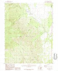
1986 Map of New Harmony
USGS Topo · Published 1987About this map
New Harmony sits at the base of the Pine Valley Mountains, serving as a gateway to the high-elevation wilderness of the Dixie National Forest. This 1970s-era field survey documents the complex drainage systems of the eastern Great Basin, where waterways like Ash Creek and Pinto Creek carve through the dramatic topography of Straight Canyon and Sawyer Canyon. The map reveals a landscape defined by seasonal water sources and early infrastructure, from the small Cem just south of the town center to more remote landmarks like Anderson Dam and Comanche Spring. Deep in the forest, the terrain rises toward Mount Baldy and Rocky Knoll, while specialized local naming such as Death Valley and Maple Hollow reflects the varied character of the canyons and washes that define this portion of the Washington and Iron County line.
Find a feature on this map
36 named features on this map. Tap any name to fly to it.
Don’t see what you’re looking for? This feature index may not catch every label — zoom into the map to look around manually.
Map Details
Editions of this 1986 New Harmony Map
2 editions found
Other maps of this area

1885 · St. George
USGS Topo · 1:250,000

1891 · St. George
USGS Topo · 1:250,000

1950 · Kanarraville
USGS Topo · 1:24,000

1950 · Iron Mountain
USGS Topo · 1:62,500

1950 · Cedar City
USGS Topo · 1:62,500

1950 · Stoddard Mtn
USGS Topo · 1:24,000

1950 · Page Ranch
USGS Topo · 1:24,000

1951 · Kanarraville
USGS Topo · 1:24,000

1951 · Stoddard Mtn
USGS Topo · 1:24,000

1951 · Page Ranch
USGS Topo · 1:24,000