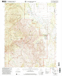
2002 Map of New Harmony
USGS Topo · Published 2005About this map
New Harmony sits at the foot of the Pine Valley Mountains, serving as a gateway to the high-elevation terrain of the Dixie National Forest. This 2002 revision shows the intersection of livestock ranching and conservation, with the Pine Valley Wilderness Boundary demarcating protected lands to the west. The landscape is defined by dramatic elevation changes, from the heights of Mount Baldy and Big Point down to the drainage networks of Ash Creek and Kanarra Creek. Local history is anchored by the Cem near the town center and scattered outposts like Page Ranch. The network of 4wd roads and a Pipeline trace the modern human footprint through a terrain carved by Straight Canyon, Main Canyon, and Maple Hollow. The map also captures the transition between the Washington and Iron county lines, illustrating the rural isolation and topographical complexity of southwestern Utah.
Find a feature on this map
57 named features on this map. Tap any name to fly to it.
Don’t see what you’re looking for? This feature index may not catch every label — zoom into the map to look around manually.
Map Details
Editions of this 2002 New Harmony Map
2 editions found
Other maps of this area

1885 · St. George
USGS Topo · 1:250,000

1891 · St. George
USGS Topo · 1:250,000

1950 · Kanarraville
USGS Topo · 1:24,000

1950 · Iron Mountain
USGS Topo · 1:62,500

1950 · Cedar City
USGS Topo · 1:62,500

1950 · Stoddard Mtn
USGS Topo · 1:24,000

1950 · Page Ranch
USGS Topo · 1:24,000

1951 · Kanarraville
USGS Topo · 1:24,000

1951 · Stoddard Mtn
USGS Topo · 1:24,000

1951 · Page Ranch
USGS Topo · 1:24,000