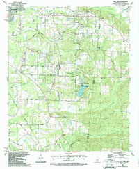
1987 Map of New Hope
USGS Topo · Published 1987About this map
Lake Lowndes State Park anchors the central landscape of this 1980s survey, illustrating the intersection of recreation and rural industry along the Mississippi Alabama border. The settlement of New Hope and the nearby McCrary community are defined by a network of rural routes like Old Airline Road and Golden Road, alongside the tracks of the Gulf and Mississippi. The map reveals a deeply rooted community structure, evidenced by numerous country churches such as Beersheba Cumberland Ch, Marrshs Chapel, and Baptist Grove Ch. To the south, an Abandoned Landing Field and numerous Gravel Pits suggest shifting land use and local industry. The drainage of Ellis Creek, Nash Creek, and Greens Creek through the wooded terrain highlights the area's natural topography before it reaches the Columbus outskirts.
Find a feature on this map
51 named features on this map. Tap any name to fly to it.
Don’t see what you’re looking for? This feature index may not catch every label — zoom into the map to look around manually.
Map Details
Editions of this 1987 New Hope Map
This is the sole edition of this map. No revisions or reprints were ever made.
Other maps of this area

1953 · West Point
USGS Topo · 1:250,000

1958 · West Point
USGS Topo · 1:250,000

1960 · Caledonia
USGS Topo · 1:62,500

1960 · Columbus
USGS Topo · 1:62,500

1963 · West Point
USGS Topo · 1:250,000

1966 · Ethelsville
USGS Topo · 1:24,000

1966 · Reform SW
USGS Topo · 1:24,000

1967 · Fernbank
USGS Topo · 1:24,000

1982 · West Point
USGS Topo · 1:100,000

1984 · West Point
USGS Topo · 1:250,000