
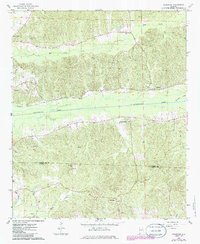
1967 Map of Fernbank
USGS Topo · Published 1968About this map
The community of Fernbank serves as the focal point of this West Alabama landscape, situated along the Southern railroad line as it traverses the central valley. The terrain is defined by the broad floodplain of Luxapallila Creek, which dominates the midsection of the quadrangle and is fed by tributaries like Mud Creek and Brushy Creek. This area illustrates the classic rural settlement patterns of the late 1960s, where small community life centered on numerous country churches including Reeves Chapel, Ebenezer Ch, and Friendship Ch.
Find a feature on this map
19 named features on this map. Tap any name to fly to it.
Don’t see what you’re looking for? This feature index may not catch every label — zoom into the map to look around manually.
Map Details
Editions of this 1967 Fernbank Map
2 editions found
Other maps of this area

1953 · West Point
USGS Topo · 1:250,000

1958 · West Point
USGS Topo · 1:250,000

1960 · Caledonia
USGS Topo · 1:62,500

1960 · Columbus
USGS Topo · 1:62,500

1963 · West Point
USGS Topo · 1:250,000

1966 · Ethelsville
USGS Topo · 1:24,000

1967 · Hightogy
USGS Topo · 1:24,000

1967 · Millport
USGS Topo · 1:24,000

1967 · Millport NW
USGS Topo · 1:24,000
1967 · Reform
USGS Topo · 1:24,000