1908 Map of New Kensington
USGS Topo · Published 1956About this map
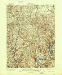
The Allegheny River corridor north of Pittsburgh serves as the focal point of this early twentieth-century survey, showcasing a landscape transitioning from rural townships to a networked industrial valley. The river serves as a major transportation artery, with Twelvemile Island and the Fulton Ferry crossing punctuating its course. Inland, the high ground is defined by scattered settlements like Saxonburg and Bakerstown, while the narrow valleys provide passage for the Pennsylvania RR and the Pittsburgh and Western RR. These rail lines fostered the growth of commuter and industrial stops such as Allison Park Sta and Bakerstown Sta. Local life at this time centered on small rural institutions, including the Sandy Hill School and Clinton Church, while the numerous runs and creeks, such as Little Deer Creek and Glade Run, illustrate the complex drainage patterns that dictated early road and settlement placement.
Find a feature on this map
97 named features on this map. Tap any name to fly to it.
Don’t see what you’re looking for? This feature index may not catch every label — zoom into the map to look around manually.
Map Details
Editions of this 1908 New Kensington Map
This is the sole edition of this map. No revisions or reprints were ever made.