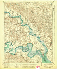
1919 Map of New Kent
USGS Topo · Published 1930About this map
The confluence of the Mattaponi River and the Pamunkey River forms the York River at West Point, a significant rail-and-river hub during the late 1910s. This survey, conducted by J.I. Gayetty and others, documents a landscape defined by extensive wetlands such as Cousaic Marsh and Eltham Marsh. To the west, the Pamunkey Indian Reservation sits along a sharp bend in the river, while the local economy is illustrated by landings like Whiteoak Landing and Courthouse Landing. Transportation depends on a mix of old and new infrastructure, from the Southern railroad line serving Cohoke Sta to the Sweet Hall Ferry and the Gresham Bridge. Throughout the region, small social centers are anchored by landmarks like Mattaponi Church and local education sites including Bunker Hill School and the Mitchell Hill School.
Find a feature on this map
87 named features on this map. Tap any name to fly to it.
Don’t see what you’re looking for? This feature index may not catch every label — zoom into the map to look around manually.
Map Details
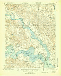
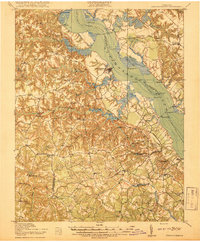
Editions of this 1919 New Kent Map
3 editions found
Other maps of this area

1906 · Williamsburg
USGS Topo · 1:62,500

1917 · Urbanna
USGS Topo · 1:62,500

1917 · Morattico
USGS Topo · 1:62,500

1917 · Toano
USGS Topo · 1:62,500

1918 · Charles City
USGS Topo · 1:62,500

1918 · Toano
USGS Topo · 1:62,500
1918 · Tappahannock
USGS Topo · 1:62,500

1918 · Aylett
USGS Topo · 1:62,500

1918 · Morattico
USGS Topo · 1:62,500

1919 · New Kent
USGS Topo · 1:62,500