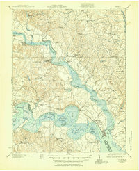
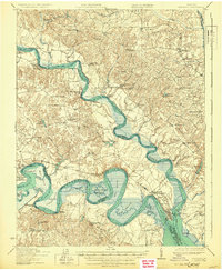
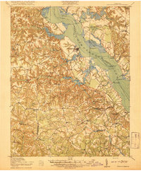
1919 Map of New Kent
USGS Topo · Published 1951About this map
The confluence of the Mattaponi River and the Pamunkey River at West Point defines this coastal Virginia landscape, where maritime and rail transport intersect. Surveyed just after the Great War, the sheet captures a network of historic river crossings and landings, including Frazier Ferry, Whiteoak Landing, and Scotland Landing, alongside the newly constructed Lord Delaware Bridge. These waterways serve as the borders for the Mattaponi Indian Reservation and Pamunkey Indian Reservation, which remain prominent landmarks of the region's indigenous heritage.
Find a feature on this map
102 named features on this map. Tap any name to fly to it.
Don’t see what you’re looking for? This feature index may not catch every label — zoom into the map to look around manually.
Map Details
Editions of this 1919 New Kent Map
3 editions found
Other maps of this area

1906 · Williamsburg
USGS Topo · 1:62,500

1917 · Urbanna
USGS Topo · 1:62,500

1917 · Morattico
USGS Topo · 1:62,500

1917 · Toano
USGS Topo · 1:62,500

1918 · Charles City
USGS Topo · 1:62,500

1918 · Toano
USGS Topo · 1:62,500
1918 · Tappahannock
USGS Topo · 1:62,500

1918 · Aylett
USGS Topo · 1:62,500

1918 · Morattico
USGS Topo · 1:62,500

1919 · New Kent
USGS Topo · 1:62,500