1949 Map of New Kent
USGS Topo · Published 1949About this map
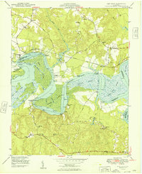
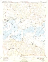
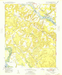
The Pamunkey River winds through this coastal Virginia landscape, defining a network of landings and marshes essential to the mid-century river economy. Along its banks, the Pamunkey Indian Reservation sits adjacent to Lester Manor and West Island, highlighting a deep cultural geography. The Southern railroad cuts through the terrain, connecting small settlements like Lanesville and Cohoke to larger regional transit. Local community life is documented through numerous country churches and schools, such as St Johns Ch and New Cumberland Sch.
Find a feature on this map
57 named features on this map. Tap any name to fly to it.
Don’t see what you’re looking for? This feature index may not catch every label — zoom into the map to look around manually.
Map Details
Editions of this 1949 New Kent Map
2 editions found
Other maps of this area

1917 · Toano
USGS Topo · 1:62,500

1918 · Charles City
USGS Topo · 1:62,500

1918 · Toano
USGS Topo · 1:62,500

1919 · New Kent
USGS Topo · 1:62,500

1920 · King William
USGS Topo · 1:62,500

1943 · Richmond
USGS Topo · 1:250,000

1949 · Truhart
USGS Topo · 1:24,000
1949 · King William
USGS Topo · 1:24,000

1949 · King And Queen
USGS Topo · 1:24,000

1949 · Tunstall
USGS Topo · 1:24,000