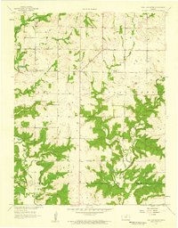
1957 Map of New Lancaster
USGS Topo · Published 1959About this map
New Lancaster serves as the focal point of this 1957 landscape, situated in a region defined by the winding paths of North Sugar Creek and Middle Creek. The map documents a rural transition where traditional farming meets early energy extraction, evidenced by the presence of Oil Wells and a Quarry dotting the terrain. This area, straddling the Miami Co Linn Co boundary, preserves the locations of vital community centers such as the Town Hall and Drexel Corner. Genealogists will find particular value in the clearly marked locations of New Lancaster Cem, Rockville Cem, and Jingo Cem, which anchor the local family histories of the Lincoln and Sugar Creek townships. The network of unimproved dirt roads and light-duty paths illustrates a mid-century rural infrastructure before the widespread modernization of the Kansas interior.
Find a feature on this map
16 named features on this map. Tap any name to fly to it.
Don’t see what you’re looking for? This feature index may not catch every label — zoom into the map to look around manually.
Map Details
Editions of this 1957 New Lancaster Map
2 editions found
Other maps of this area

1887 · Olathe
USGS Topo · 1:125,000

1887 · Mound City
USGS Topo · 1:125,000

1893 · Mound City
USGS Topo · 1:125,000

1893 · Olathe
USGS Topo · 1:125,000

1947 · Lawrence
USGS Topo · 1:250,000

1950 · Lawrence
USGS Topo · 1:250,000

1953 · Freeman
USGS Topo · 1:24,000

1956 · Paola East
USGS Topo · 1:24,000

1956 · Lawrence
USGS Topo · 1:250,000
1957 · Louisburg
USGS Topo · 1:24,000