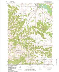
1983 Map of New Lisbon South
USGS Topo · Published 1984About this map
The Lemonweir River winds through the northeast corner of this 1983 Wisconsin survey, where the Chicago Milwaukee St Paul and Pacific railroad parallels its course near New Lisbon. The landscape is defined by a dense network of ridges and valleys, including Norwegian Gap, Suldal Valley, and Duckworth Ridge. This topography has historically dictated settlement patterns, with family-named burial grounds like Zindorf Cem and East Lemonweir Cem marking the high ground above the creek beds. Rural life in the townships of Fountain, Plymouth, and Lindina is evidenced by numerous small-scale industrial sites, such as the Quarry and various Sandpit locations. The southern portion of the map reveals a complex drainage system where Onemile Creek and Cleaver Creek cut through the terrain, supporting scattered farmsteads connected by a grid of named roads including Suldal Road and Norton Road.
Find a feature on this map
53 named features on this map. Tap any name to fly to it.
Don’t see what you’re looking for? This feature index may not catch every label — zoom into the map to look around manually.
Map Details
Editions of this 1983 New Lisbon South Map
This is the sole edition of this map. No revisions or reprints were ever made.
Other maps of this area

1919 · Kendall
USGS Topo · 1:62,500

1921 · Mauston
USGS Topo · 1:62,500

1921 · Kendall
USGS Topo · 1:62,500

1927 · Hillsboro
USGS Topo · 1:62,500

1956 · Reedsburg
USGS Topo · 1:62,500

1958 · La Crosse
USGS Topo · 1:250,000

1961 · La Crosse
USGS Topo · 1:250,000

1962 · Kendall
USGS Topo · 1:62,500

1962 · Mauston
USGS Topo · 1:62,500

1965 · La Crosse
USGS Topo · 1:250,000