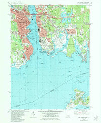
1984 Map of New London
USGS Topo · Published 1984About this map
The Thames River serves as the central artery for this maritime region, separating the industrial and academic hub of New London from the residential and military landscapes of Groton. Dominating the western bank, the US Coast Guard Academy and Mitchell College stand alongside major rail corridors like the Amtrak and Central Vermont lines. Across the water, the legacy of coastal defense is prominent at Fort Griswold State Park and the sprawling Fort Trumbull USN Res. The map captures a moment when the regional infrastructure was heavily defined by cold war naval operations, evidenced by the Naval Underwater Systems Center on Fishers Island. To the south, the transition from urban density to protected coastal environments is marked by Harkness Memorial State Park and the distinctive peninsula of Bluff Point State Park, protecting the mouth of the Poquonock River.
Find a feature on this map
117 named features on this map. Tap any name to fly to it.
Don’t see what you’re looking for? This feature index may not catch every label — zoom into the map to look around manually.
Map Details
Editions of this 1984 New London Map
2 editions found
Other maps of this area

1889 · Stonington
USGS Topo · 1:62,500

1892 · New London
USGS Topo · 1:62,500

1893 · Stonington
USGS Topo · 1:62,500

1893 · New London
USGS Topo · 1:62,500

1903 · Gardiners Island
USGS Topo · 1:62,500

1904 · Gardiners Island
USGS Topo · 1:62,500

1904 · Montauk
USGS Topo · 1:62,500

1921 · Gardiners Island
USGS Topo · 1:62,500

1921 · New London
USGS Topo · 1:62,500

1921 · Stonington
USGS Topo · 1:62,500