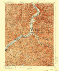
1926 Map of New Martinsville
USGS Topo · Published 1942About this map
The Ohio River forms the backbone of this 1920s-era survey, serving as the vital conduit for the Baltimore and Ohio railroad and the clusters of industrial and residential growth at New Martinsville and Sistersville. This stretch of the valley is characterized by deep river bottoms like Wells Bottom and Buck Hill Bottom, where agriculture and industry met at the water's edge. Inland, the map reveals a dense network of upland communities defined by one-room schoolhouses and country chapels, such as Democracy School and German Baptist Church. The presence of the County Infirmary near Steelton and Winders Mill on the Ohio side suggests the established social and economic infrastructure of the period. Genealogists can trace family footprints across numerous named ridges and runs, including Chiselfinger Ridge and Pursley Creek, which remained largely rural as the river towns modernized.
Find a feature on this map
146 named features on this map. Tap any name to fly to it.
Don’t see what you’re looking for? This feature index may not catch every label — zoom into the map to look around manually.
Map Details
Editions of this 1926 New Martinsville Map
2 editions found

Other maps of this area

1903 · Littleton
USGS Topo · 1:62,500

1904 · Cameron
USGS Topo · 1:62,500

1905 · Centerpoint
USGS Topo · 1:62,500

1905 · West Union
USGS Topo · 1:62,500

1905 · Littleton
USGS Topo · 1:62,500

1905 · Clarington
USGS Topo · 1:62,500

1905 · New Matamoras
USGS Topo · 1:62,500

1905 · Woodsfield
USGS Topo · 1:62,500

1906 · Saint Marys
USGS Topo · 1:62,500

1906 · New Martinsville
USGS Topo · 1:62,500