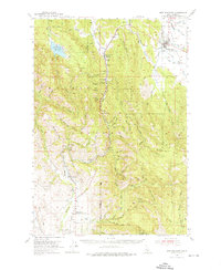
1954 Map of New Meadows
USGS Topo · Published 1976About this map
The Little Salmon River and Weiser River watersheds define this mid-century look at Adams County, where the Union Pacific railroad tracks trace a winding path through the valley floors. Settlement is concentrated along these transit corridors, connecting small community hubs like Tamarack, Evergreen, and Fruitvale. The Boise Meridian divides the landscape, separating the high country of the Payette National Forest from the lower agricultural and ranching valleys.
Find a feature on this map
60 named features on this map. Tap any name to fly to it.
Don’t see what you’re looking for? This feature index may not catch every label — zoom into the map to look around manually.
Map Details
Editions of this 1954 New Meadows Map
2 editions found
Other maps of this area

1911 · Meadows
USGS Topo · 1:125,000

1920 · Seven Devils Mining District
USGS Topo · 1:48,000

1938 · Riggins
USGS Topo · 1:96,000

1945 · Riggins
USGS Topo · 1:125,000

1954 · Council
USGS Topo · 1:62,500

1954 · New Meadows
USGS Topo · 1:62,500

1954 · Cascade
USGS Topo · 1:62,500

1955 · Baker
USGS Topo · 1:250,000

1955 · Grangeville
USGS Topo · 1:250,000

1957 · Cambridge
USGS Topo · 1:62,500