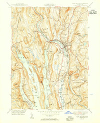
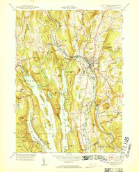
1951 Map of New Milford
USGS Topo · Published 1951About this map
The Housatonic River and the massive expanse of Candlewood Lake dominate this Litchfield County landscape, reflecting the post-war balance between industrial heritage and emerging recreational use. In the town of New Milford, the New York New Haven and Hartford railroad tracks follow the river valley, passing the Hydroelectric Plant and local industry like the Lime Kiln near Boardman Bridge.
Find a feature on this map
111 named features on this map. Tap any name to fly to it.
Don’t see what you’re looking for? This feature index may not catch every label — zoom into the map to look around manually.
Map Details
Editions of this 1951 New Milford Map
2 editions found
Other maps of this area

1892 · Danbury
USGS Topo · 1:62,500

1892 · New Milford
USGS Topo · 1:62,500

1892 · Carmel
USGS Topo · 1:62,500

1893 · Carmel
USGS Topo · 1:62,500

1893 · New Milford
USGS Topo · 1:62,500

1893 · Clove
USGS Topo · 1:62,500

1894 · Clove
USGS Topo · 1:62,500

1894 · Carmel
USGS Topo · 1:62,500

1898 · Clove
USGS Topo · 1:62,500

1901 · Clove
USGS Topo · 1:62,500