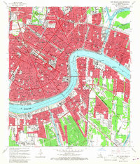
1966 Map of New Orleans East
USGS Topo · Published 1967About this map
The Mississippi River winds through the heart of the city, defining the dense urban grid of the Vieux Carre and the surrounding neighborhoods during the mid-1960s. This survey illustrates the deep integration of water and industry, showing the Inner Harbor Navigation Canal and the Turning Basin connecting the river to the Intracoastal Waterway. The landscape is marked by historic burial grounds including Metairie Cemetery and Lafayette Cem, while the cultural footprint of the era is preserved through landmarks like the Fairgrounds Racetrack and the Sugar Bowl stadium. On the west bank, communities like McDonoghville and Gretna are linked to the city center by the Greater New Orleans Bridge, reflecting the post-war expansion and transit infrastructure that shaped the modern metropolitan area.
Find a feature on this map
68 named features on this map. Tap any name to fly to it.
Don’t see what you’re looking for? This feature index may not catch every label — zoom into the map to look around manually.
Map Details
Editions of this 1966 New Orleans East Map
5 editions found

Other maps of this area

1891 · Spanish Fort
USGS Topo · 1:62,500

1891 · New Orleans
USGS Topo · 1:62,500

1892 · Chef Menteur
USGS Topo · 1:62,500

1892 · St. Bernard
USGS Topo · 1:62,500

1932 · New Orleans NE
USGS Topo · 1:31,680

1932 · New Orleans NW
USGS Topo · 1:31,680

1932 · New Orleans SE
USGS Topo · 1:31,680

1932 · New Orleans SW
USGS Topo · 1:31,680

1936 · Chef Menteur
USGS Topo · 1:62,500

1936 · Spanish Fort
USGS Topo · 1:62,500