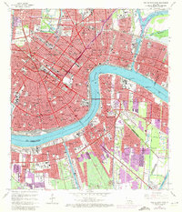
1966 Map of New Orleans East
USGS Topo · Published 1973About this map
The Vieux Carre and the dense urban core of New Orleans anchor this mid-1960s survey, illustrating a city defined by its relationship with the Mississippi River. Purple overprinting from 1972 revisions highlights the expansion of the metropolitan area, particularly the growth of suburban communities like Terrytown and the industrial development flanking the Harvey Canal. The intricate network of the New Orleans Public Belt RR and the New Orleans and Lower Coast RR reflects a heavy reliance on rail for port logistics. Beyond the historic center, the map identifies significant cultural and institutional landmarks such as Dillard University and Tulane University, alongside the vast grounds of Metairie Cemetery and the Fairgrounds Racetrack. This edition captures the city before later modern developments, showing the established footprints of neighborhoods from Algiers to Arabi at the height of the mid-century era.
Find a feature on this map
60 named features on this map. Tap any name to fly to it.
Don’t see what you’re looking for? This feature index may not catch every label — zoom into the map to look around manually.
Map Details
Editions of this 1966 New Orleans East Map
5 editions found

Other maps of this area

1891 · Spanish Fort
USGS Topo · 1:62,500

1891 · New Orleans
USGS Topo · 1:62,500

1892 · Chef Menteur
USGS Topo · 1:62,500

1892 · St. Bernard
USGS Topo · 1:62,500

1932 · New Orleans NE
USGS Topo · 1:31,680

1932 · New Orleans NW
USGS Topo · 1:31,680

1932 · New Orleans SE
USGS Topo · 1:31,680

1932 · New Orleans SW
USGS Topo · 1:31,680

1936 · Chef Menteur
USGS Topo · 1:62,500

1936 · Spanish Fort
USGS Topo · 1:62,500