
1983 Map of New Orleans
USGS Topo · Published 1983About this map
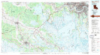
The Mississippi River anchors this regional perspective, winding through the industrial and residential corridors of New Orleans, Metairie, and Kenner before turning south toward the gulf. The landscape is defined by the complex transition from high ground to wetlands, where the Catahoula Ridge and Johnson Ridge offer footing for settlements amidst a vast network of water bodies like Lake Salvador and Lac des Allemands. This era shows the established rail infrastructure of the Southern Pacific and Texas & Pacific railroads, which facilitated the movement of goods through the river parishes.
Find a feature on this map
220 named features on this map. Tap any name to fly to it.
Don’t see what you’re looking for? This feature index may not catch every label — zoom into the map to look around manually.
Map Details
Editions of this 1983 New Orleans Map
2 editions found
Other maps of this area

1891 · Hahnville
USGS Topo · 1:62,500

1891 · Spanish Fort
USGS Topo · 1:62,500

1891 · Pointe a La Hache
USGS Topo · 1:62,500

1891 · New Orleans
USGS Topo · 1:62,500

1892 · Barataria
USGS Topo · 1:62,500

1892 · Lac Des Allemands
USGS Topo · 1:62,500

1892 · Chef Menteur
USGS Topo · 1:62,500

1892 · Mount Airy
USGS Topo · 1:62,500

1892 · Gibson
USGS Topo · 1:62,500

1892 · Bonnet Carre
USGS Topo · 1:62,500