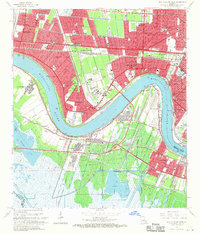
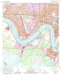
1965 Map of New Orleans West
USGS Topo · Published 1971About this map
The Mississippi River dominates this mid-1960s landscape, winding past the industrial and residential corridors of Kenner, Metairie, and Westwego. The era's heavy reliance on river-and-rail logistics is evident in the dense concentration of infrastructure, from the Huey P Long Bridge spanning the water to the extensive rail networks of the Illinois Central Railroad and Southern Pacific Railroad. The map reveals a transition from the urban density of New Orleans and its neighborhood landmarks like Audubon Park to the emerging suburban developments of Bonnabel Place and Westgate. South of the river, the Westwego Oil and Gas Field and numerous canals like the Avondale Canal reflect the region's energy and maritime economy. Local history is preserved through dozens of parish schools and cemeteries, including the Garden of Memories (Cemetery) and institutions like St Marys College.
Find a feature on this map
81 named features on this map. Tap any name to fly to it.
Don’t see what you’re looking for? This feature index may not catch every label — zoom into the map to look around manually.
Map Details
Editions of this 1965 New Orleans West Map
5 editions found
Other maps of this area

1891 · Hahnville
USGS Topo · 1:62,500

1891 · Spanish Fort
USGS Topo · 1:62,500

1891 · New Orleans
USGS Topo · 1:62,500

1892 · Bonnet Carre
USGS Topo · 1:62,500

1932 · New Orleans NE
USGS Topo · 1:31,680

1932 · New Orleans NW
USGS Topo · 1:31,680

1932 · New Orleans SE
USGS Topo · 1:31,680

1932 · New Orleans SW
USGS Topo · 1:31,680

1932 · Hahnville NE
USGS Topo · 1:31,680

1935 · Luling
USGS Topo · 1:31,680