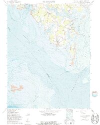
1964 Map of New Point Comfort
USGS Topo · Published 1987About this map
New Point Comfort stands at the tip of this coastal landscape, where the tides of Mobjack Bay and the Chesapeake Bay meet. The 1963-1965 survey data, updated with bathymetry in the mid-1980s, reveals a maritime-focused environment of points and necks defined by intricate water bodies like Horn Harbor and Pepper Creek. Small waterfront settlements such as Shadow, Bayside, and Bavon are scattered throughout the peninsula, connected by light-duty roads that pass through rural communities.
Find a feature on this map
43 named features on this map. Tap any name to fly to it.
Don’t see what you’re looking for? This feature index may not catch every label — zoom into the map to look around manually.
Map Details
Editions of this 1964 New Point Comfort Map
2 editions found
Other maps of this area

1907 · Hampton
USGS Topo · 1:62,500

1916 · Mathews
USGS Topo · 1:62,500

1917 · Mathews
USGS Topo · 1:62,500

1943 · Richmond
USGS Topo · 1:250,000

1944 · Messick
USGS Topo · 1:24,000

1944 · Harris Grove
USGS Topo · 1:24,000

1948 · Ware Neck
USGS Topo · 1:24,000

1948 · Achilles
USGS Topo · 1:24,000

1948 · New Point Comfort
USGS Topo · 1:24,000

1948 · Mathews
USGS Topo · 1:24,000