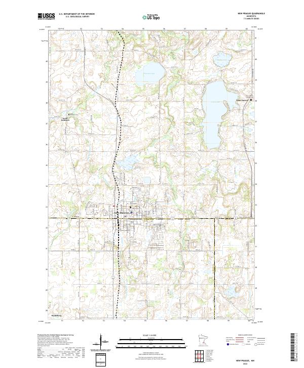
2022 Map of New Prague
USGS Topo · Published 2022About this map
New Prague sits at a three-way county junction where Scott, Le Sueur, and Rice counties meet, serving as a regional anchor for the surrounding agricultural landscape. This 2022 survey details the intricate drainage system defined by Sand Cr, Raven Stream, and several smaller tributaries like Philipps Cr and Porter Cr. The map highlights the area's spiritual and genealogical history through sites like Saint Wenceslaus Cem in the heart of town and outlying parishes such as Saint Benedict and Saint Patrick, each with its own associated cemetery. Large water bodies including Cedar Lake and Pleasant Lake dominate the northern half of the quadrangle. The presence of County Ditch Number Sixty-two reflects the long-term management of the prairie wetlands for farming, a defining characteristic of this part of Minnesota.
Find a feature on this map
128 named features on this map. Tap any name to fly to it.
Don’t see what you’re looking for? This feature index may not catch every label — zoom into the map to look around manually.
Map Details
Editions of this 2022 New Prague Map
This is the sole edition of this map. No revisions or reprints were ever made.
Other maps of this area

1953 · Saint Paul
USGS Topo · 1:250,000

1957 · Prior Lake
USGS Topo · 1:62,500

1957 · New Prague
USGS Topo · 1:62,500

1959 · Saint Paul
USGS Topo · 1:250,000

1960 · Lonsdale
USGS Topo · 1:24,000

1966 · Montgomery
USGS Topo · 1:24,000

1966 · Le Center
USGS Topo · 1:24,000
1974 · Prior Lake
USGS Topo · 1:24,000
1974 · Veseli
USGS Topo · 1:24,000
1981 · New Prague
USGS Topo · 1:24,000