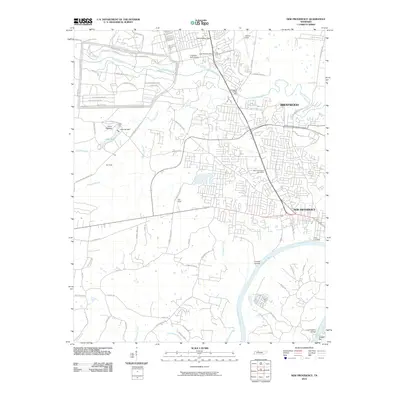
2010 Map of New Providence
USGS Topo · Published 2010About this map
Fort Campbell occupies the northern half of this landscape, its military infrastructure defined by a complex grid of tactical routes like 101st Airborne Division Rd and 11th Airborne Division Rd. The southern portion of the map transitions into the residential and commercial areas of New Providence and Brentwood, clustered along the corridors leading toward the Cumberland River. Notable landmarks reflecting the area's mixed military and civilian character include Camp Tagaytay near Lake Taal and the New Providence Post Office. Along the river, historical points of interest such as Ringgold Creek Mill and Trice Landing highlight the importance of water access for early industry and transport, while the Cunningham Bridge provides a vital southern connection.
Find a feature on this map
76 named features on this map. Tap any name to fly to it.
Don’t see what you’re looking for? This feature index may not catch every label — zoom into the map to look around manually.
Map Details
Editions of this 2010 New Providence Map
This is the sole edition of this map. No revisions or reprints were ever made.
Other maps of this area

1931 · Erin
USGS Topo · 1:62,500

1944 · Clarksville
USGS Topo · 1:50,000

1951 · New Providence
USGS Topo · 1:24,000

1951 · Hammacksville
USGS Topo · 1:24,000

1951 · Clarksville
USGS Topo · 1:24,000

1951 · Herndon
USGS Topo · 1:24,000

1951 · Oak Grove
USGS Topo · 1:24,000

1951 · Woodlawn
USGS Topo · 1:24,000

1956 · Nashville
USGS Topo · 1:250,000

1957 · New Providence
USGS Topo · 1:24,000
Featured Places
- Clarksville, TN
- Belleglade Mobile Home Community, Clarksville
- Briarwood, TN
- Two Rivers District, Clarksville
- New Providence, Clarksville