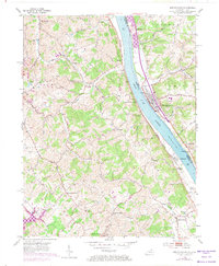
1953 Map of New Richmond
USGS Topo · Published 1974About this map
The Ohio River defines this mid-century landscape, separating the riverfront commerce of New Richmond in Ohio from the rural hillsides of Campbell County, Kentucky. This 1953 survey, with revisions from 1972, documents a period of transition along the river corridor, where the Chesapeake and Ohio railroad follows the Kentucky bank through Oneonta and past New Richmond Sta. Further inland, the topography is deeply dissected by drainage systems like Twelvemile Creek and Fourmile Creek. Small community hubs and agricultural settlements such as Persimmon Grove, Carthage, and Flagg Spring are marked by landmark institutions including the Sts Peter & Paul Sch and Twelvemile Ch. Significant genealogical data is present through numerous family and community burial grounds, such as Watkins Cem and Moreland Cem, located near the Bethel - New Richmond Road.
Find a feature on this map
47 named features on this map. Tap any name to fly to it.
Don’t see what you’re looking for? This feature index may not catch every label — zoom into the map to look around manually.
Map Details
Editions of this 1953 New Richmond Map
3 editions found

Other maps of this area

1898 · East Cincinnati
USGS Topo · 1:62,500

1914 · East Cincinnati
USGS Topo · 1:62,500

1914 · Batavia
USGS Topo · 1:48,000

1916 · Batavia
USGS Topo · 1:62,500

1929 · Alexandria
USGS Topo · 1:48,000

1931 · Felicity
USGS Topo · 1:62,500

1936 · Alexandria
USGS Topo · 1:62,500

1952 · Newport
USGS Topo · 1:24,000

1953 · Laurel
USGS Topo · 1:24,000

1953 · Withamsville
USGS Topo · 1:24,000