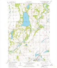
1974 Map of New Richmond North
USGS Topo · Published 1977About this map
Star Prairie and the surrounding townships of Alden and Farmington are defined by the winding course of the Apple River as it moves toward its confluence with the St. Croix River. This mid-1970s survey captures a landscape of small settlements and rural infrastructure, from the lakeside community at Cedar Lake to the scattered hamlets of Huntington and Johannesburg. The industrial and transport history of the region is evident in the path of the Chicago and North Western and Soo Line railroads, alongside localized operations like the Gravel Pits and the Riverdale Flowage. The map also documents essential community landmarks including Oakland Cem, the Cedar Lake Sch, and the St Croix Health Center, providing a detailed look at the social and economic geography of northwestern Wisconsin during this era.
Find a feature on this map
34 named features on this map. Tap any name to fly to it.
Don’t see what you’re looking for? This feature index may not catch every label — zoom into the map to look around manually.
Map Details
Editions of this 1974 New Richmond North Map
This is the sole edition of this map. No revisions or reprints were ever made.
Other maps of this area

1900 · St Croix Dalles
USGS Topo · 1:62,500

1901 · St Croix Dalles
USGS Topo · 1:62,500

1948 · New Richmond
USGS Topo · 1:62,500

1949 · New Richmond
USGS Topo · 1:62,500

1950 · Deer Park
USGS Topo · 1:62,500

1950 · Balsam Lake
USGS Topo · 1:62,500

1953 · Stillwater
USGS Topo · 1:250,000

1955 · St. Croix Dalles
USGS Topo · 1:62,500

1955 · Stillwater
USGS Topo · 1:250,000

1958 · Stillwater
USGS Topo · 1:250,000