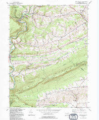
1992 Map of New Ringgold
USGS Topo · Published 1994About this map
Little Schuylkill River carves through the central terrain of this quadrangle, flanked by the prominent ridge of Blue Mountain. The map illustrates a landscape shaped by transportation and conservation, where an Abandoned Railroad and Old RR Grade run parallel to the water, marking the evolution of coal-era transit. Cultural life is anchored by numerous rural institutions, including Zions Ch, West Penn Ch, and Sassamans Sch, reflecting the deep-rooted community history of East Brunswick and West Penn townships.
Find a feature on this map
63 named features on this map. Tap any name to fly to it.
Don’t see what you’re looking for? This feature index may not catch every label — zoom into the map to look around manually.
Map Details
Editions of this 1992 New Ringgold Map
This is the sole edition of this map. No revisions or reprints were ever made.
Other maps of this area

1889 · Hazleton
USGS Topo · 1:62,500

1889 · Pottsville
USGS Topo · 1:62,500

1891 · Hazleton
USGS Topo · 1:62,500

1891 · Pottsville
USGS Topo · 1:62,500

1892 · Mahanoy
USGS Topo · 1:62,500

1893 · Hazleton
USGS Topo · 1:62,500

1893 · Mahanoy
USGS Topo · 1:62,500

1909 · Hamburg
USGS Topo · 1:62,500

1911 · Hamburg
USGS Topo · 1:62,500

1944 · Orwigsburg
USGS Topo · 1:24,000
Featured Places
- West Penn Township, PA
- Albany Township, PA
- New Ringgold, PA
- Kepner, West Penn Township
- West Brunswick Township, PA