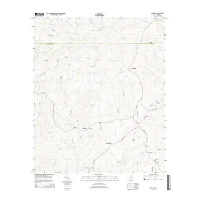
2014 Map of New Site
USGS Topo · Published 2014About this map
New Site and the surrounding Tallapoosa County landscape are defined by a network of small rural communities and family-named landmarks. The topography is deeply carved by waterways such as Enitachopco Creek and Pinhergut Cr, which wind through the terrain near Goldville and Cowpens. This 2014 survey reveals a high density of historical burial sites for a rural area, including Old Salem Cem, Bethlehem Cem, and Harmony Cem, which offer significant value for genealogical research. The road network, including State Highway 22 E and Al-49, connects dispersed settlements like Perryville and Fosheeton. Local landmarks such as Hog Mtn and Patterson Lake provide distinctive reference points within the wooded hills. The map provides a clear picture of contemporary rural Alabama life, where long-established church and family cemeteries remain central to the community's geographic identity.
Find a feature on this map
84 named features on this map. Tap any name to fly to it.
Don’t see what you’re looking for? This feature index may not catch every label — zoom into the map to look around manually.
Map Details
Editions of this 2014 New Site Map
This is the sole edition of this map. No revisions or reprints were ever made.
Other maps of this area

1891 · Ashland
USGS Topo · 1:125,000

1906 · Dadeville
USGS Topo · 1:125,000

1953 · Atlanta
USGS Topo · 1:250,000

1955 · Phenix City
USGS Topo · 1:250,000

1957 · Phenix City
USGS Topo · 1:250,000

1957 · Atlanta
USGS Topo · 1:250,000

1958 · Phenix City
USGS Topo · 1:250,000

1958 · Atlanta
USGS Topo · 1:250,000

1969 · New Site
USGS Topo · 1:24,000
1969 · Millerville
USGS Topo · 1:24,000