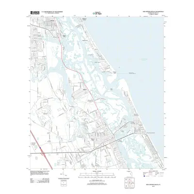
2012 Map of New Smyrna Beach
USGS Topo · Published 2012About this map
The Halifax River and Indian River North converge near the Ponce de Leon Inlet, a dynamic coastal environment where the Atlantic tide meets a complex network of marshes and cuts. This 2012 survey illustrates the modern layout of New Smyrna Beach and Coronado Beach, including the Harris Saxon Bridge and the New Smyrna Beach Municipal Airport. The landscape is defined by its waterways, from the winding Spruce Creek to the artificial Ponce de Leon Cut and Sheephead Cut. Genealogists will find significant local history preserved in various burial grounds, including the Pacetti Family Cem, Detwiller Park Cem, and Glencoe Geiger Cem. Small communities like Isleboro, Mission City, and Harbor Oaks are documented alongside navigational landmarks such as the Ponce de Leon Inlet North Jetty Light, providing a detailed view of the Volusia County coastline.
Find a feature on this map
267 named features on this map. Tap any name to fly to it.
Don’t see what you’re looking for? This feature index may not catch every label — zoom into the map to look around manually.
Map Details
Editions of this 2012 New Smyrna Beach Map
This is the sole edition of this map. No revisions or reprints were ever made.
Other maps of this area

1937 · Port Orange
USGS Topo · 1:48,000

1943 · Port Orange
USGS Topo · 1:62,500

1944 · Port Orange
USGS Topo · 1:62,500

1950 · Ariel
USGS Topo · 1:24,000

1950 · Edgewater
USGS Topo · 1:24,000

1952 · Samsula
USGS Topo · 1:24,000

1952 · Daytona Beach
USGS Topo · 1:24,000

1954 · Daytona Beach
USGS Topo · 1:250,000

1955 · Orlando
USGS Topo · 1:250,000

1956 · Port Orange
USGS Topo · 1:24,000