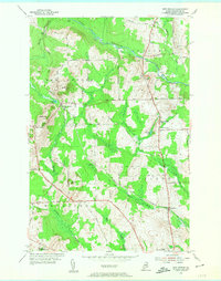
1953 Map of New Sweden
USGS Topo · Published 1955About this map
The New Sweden area of Aroostook County reflects a mid-century agricultural landscape defined by its Swedish heritage and the critical role of the Bangor and Aroostook railroad. This 1953 survey captures the interplay between small farm settlements and the rail sidings that served them, including Rista Siding and Ben Thomas Siding, which acted as vital hubs for the local potato economy. The terrain is marked by prominent elevations like Capitol Hill and Gelot Hill, while the Little Madawaska River winds through the northern section near Acadia. Educational and spiritual centers, such as the Sacred Heart Sch and Woodland Consolidated Sch, are clearly mapped, providing precise locations for genealogical researchers and local historians tracing the community structure of Northern Maine before modern consolidation changed the rural character of the region.
Find a feature on this map
46 named features on this map. Tap any name to fly to it.
Don’t see what you’re looking for? This feature index may not catch every label — zoom into the map to look around manually.
Map Details
Editions of this 1953 New Sweden Map
3 editions found
Other maps of this area

1921 · Van Buren
USGS Topo · 1:250,000

1927 · Stockholm
USGS Topo · 1:48,000

1929 · Caribou
USGS Topo · 1:48,000

1930 · Fort Fairfield
USGS Topo · 1:48,000

1931 · Van Buren
USGS Topo · 1:48,000

1931 · Stockholm
USGS Topo · 1:62,500

1932 · Caribou
USGS Topo · 1:62,500

1933 · Fort Fairfield
USGS Topo · 1:62,500

1934 · Van Buren
USGS Topo · 1:62,500

1951 · Van Buren
USGS Topo · 1:62,500