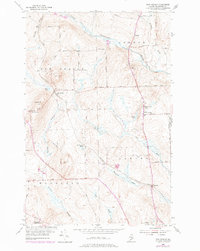
1953 Map of New Sweden
USGS Topo · Published 1978About this map
The Little Madawaska River winds through this northern Aroostook County landscape, defining a region where Swedish heritage and the potato-farming economy intersect. The settlement pattern is anchored by New Sweden and North Lyndon, with the Bangor and Aroostook railroad providing the critical link for local produce. Rail sidings like Rista Siding and Ben Thomas Siding point to a time when trackside loading was central to rural life.
Find a feature on this map
46 named features on this map. Tap any name to fly to it.
Don’t see what you’re looking for? This feature index may not catch every label — zoom into the map to look around manually.
Map Details
Editions of this 1953 New Sweden Map
3 editions found
Other maps of this area

1921 · Van Buren
USGS Topo · 1:250,000

1927 · Stockholm
USGS Topo · 1:48,000

1929 · Caribou
USGS Topo · 1:48,000

1930 · Fort Fairfield
USGS Topo · 1:48,000

1931 · Van Buren
USGS Topo · 1:48,000

1931 · Stockholm
USGS Topo · 1:62,500

1932 · Caribou
USGS Topo · 1:62,500

1933 · Fort Fairfield
USGS Topo · 1:62,500

1934 · Van Buren
USGS Topo · 1:62,500

1951 · Van Buren
USGS Topo · 1:62,500