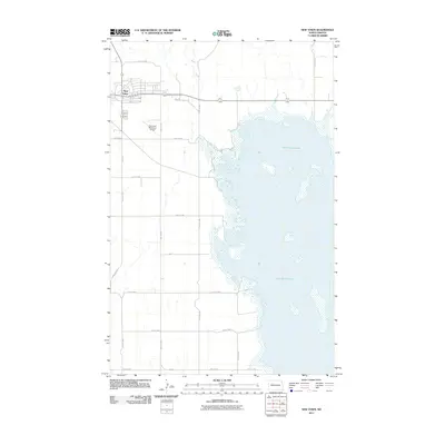
2011 Map of New Town
USGS Topo · Published 2011About this map
New Town sits as a planned settlement on the edge of the Missouri River valley, overlooking the expansive waters of Lake Sakakawea. The street grid reflects the town's modern origin, with numbered corridors like 40th St NW and College Dr framing the residential and commercial blocks. To the east of the town center, the New Town Municipal Airport provides a key transportation link for this portion of Mountrail County. The landscape is dominated by the intricate shoreline of the lake, which reaches into the local topography through several finger-like inlets and bays. A network of rural section-line roads, including 88th Ave NW and 32nd St NW, extends from the town site into the surrounding agricultural plains, mapping the late-twentieth-century transition from municipal hub to wide-open prairie.
Find a feature on this map
21 named features on this map. Tap any name to fly to it.
Don’t see what you’re looking for? This feature index may not catch every label — zoom into the map to look around manually.
Map Details
Editions of this 2011 New Town Map
This is the sole edition of this map. No revisions or reprints were ever made.
Other maps of this area

1953 · Williston
USGS Topo · 1:250,000

1953 · Watford City
USGS Topo · 1:250,000

1957 · Williston
USGS Topo · 1:250,000

1957 · Watford City
USGS Topo · 1:250,000

1967 · Watford City
USGS Topo · 1:250,000

1967 · Sanish
USGS Topo · 1:24,000

1967 · Sanish SE
USGS Topo · 1:24,000

1967 · New Town SW
USGS Topo · 1:24,000

1967 · New Town SE
USGS Topo · 1:24,000

1981 · Belden SW
USGS Topo · 1:24,000