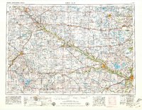
1953 Map of New Ulm
USGS Topo · Published 1979About this map
The Minnesota River valley serves as the primary artery for this mid-century look at southern Minnesota, carving a diagonal path through a landscape defined by its agricultural grid and numerous prairie lakes. Established settlements like New Ulm, Montevideo, and Mankato anchor the region's commerce, while the rail infrastructure of the Chicago and North Western RR and the Chicago Milwaukee St Paul and Pacific RR connects the smaller grain-handling towns across the plains.
Find a feature on this map
136 named features on this map. Tap any name to fly to it.
Don’t see what you’re looking for? This feature index may not catch every label — zoom into the map to look around manually.
Map Details
Editions of this 1953 New Ulm Map
3 editions found
Other maps of this area

1950 · Mankato East
USGS Topo · 1:62,500

1951 · Mankato East
USGS Topo · 1:62,500

1951 · Mankato West
USGS Topo · 1:62,500

1952 · Morton
USGS Topo · 1:62,500

1952 · Redwood Falls
USGS Topo · 1:62,500

1953 · Morgan
USGS Topo · 1:62,500

1953 · Milbank
USGS Topo · 1:250,000

1953 · Saint Paul
USGS Topo · 1:250,000

1953 · Watertown
USGS Topo · 1:250,000

1953 · New Ulm
USGS Topo · 1:250,000