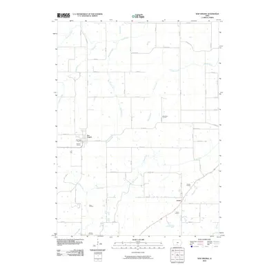
2010 Map of New Virginia
USGS Topo · Published 2010About this map
New Virginia serves as the primary hub of this Iowa landscape, where local life centers around the New Virginia Post Office and the intersection of Co Rd G76 and Co Rd R45. The surrounding township is defined by a dense network of country roads and an intricate drainage system including the South River, Squaw Creek, and Papoose Creek. For those researching family history, the map provides precise locations for numerous burial grounds, such as Beymer Cemetery near the town center and Mount Tabor Cemetery to the east. Further south, the settlement of Liberty sits near the banks of Skinaway Creek, with its own Liberty Cemetery and Rhodes Cemetery nearby. This survey illustrates a well-ordered agricultural grid typical of the region, where gravel roads like SW 98th Ave and 38th Ave navigate around winding creek beds and small timber stands.
Find a feature on this map
54 named features on this map. Tap any name to fly to it.
Don’t see what you’re looking for? This feature index may not catch every label — zoom into the map to look around manually.
Map Details
Editions of this 2010 New Virginia Map
This is the sole edition of this map. No revisions or reprints were ever made.
Other maps of this area

1931 · Indianola
USGS Topo · 1:62,500

1950 · New Virginia
USGS Topo · 1:62,500

1951 · Osceola
USGS Topo · 1:62,500

1951 · St. Charles
USGS Topo · 1:62,500

1952 · New Virginia
USGS Topo · 1:62,500

1954 · Des Moines
USGS Topo · 1:250,000

1956 · Des Moines
USGS Topo · 1:250,000

1957 · Des Moines
USGS Topo · 1:250,000

1969 · Des Moines
USGS Topo · 1:250,000
1983 · St. Charles
USGS Topo · 1:24,000