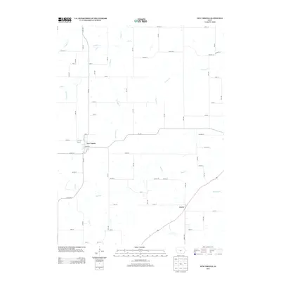
2013 Map of New Virginia
USGS Topo · Published 2013About this map
New Virginia serves as the primary hub of this southern Warren County landscape, showing a grid of residential streets including Broadway St and Main St. The town's layout is mirrored on a smaller scale to the southeast at Liberty, where the road network transitions into a more rural pattern. The terrain is defined by an intricate drainage system where S River flows through the northern reaches, fed by tributaries like Broadhorn Cr and Turkey Cr. In the southern half, the watershed is dominated by Squaw Cr, which winds through the countryside alongside Walnut Cr and Skinaway Cr. This 2013 survey illustrates the modern rural infrastructure of Virginia Township, where a dense network of numbered avenues and named streets like Roosevelt St and G76 Hwy provide access to the agricultural parcels between the wooded creek beds.
Find a feature on this map
66 named features on this map. Tap any name to fly to it.
Don’t see what you’re looking for? This feature index may not catch every label — zoom into the map to look around manually.
Map Details
Editions of this 2013 New Virginia Map
This is the sole edition of this map. No revisions or reprints were ever made.
Other maps of this area

1931 · Indianola
USGS Topo · 1:62,500

1950 · New Virginia
USGS Topo · 1:62,500

1951 · Osceola
USGS Topo · 1:62,500

1951 · St. Charles
USGS Topo · 1:62,500

1952 · New Virginia
USGS Topo · 1:62,500

1954 · Des Moines
USGS Topo · 1:250,000

1956 · Des Moines
USGS Topo · 1:250,000

1957 · Des Moines
USGS Topo · 1:250,000

1969 · Des Moines
USGS Topo · 1:250,000
1983 · St. Charles
USGS Topo · 1:24,000