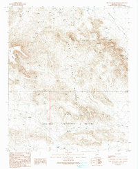
1990 Map of New Water Mountains
USGS Topo · Published 1990About this map
The New Water Mountains dominate this landscape, which is largely encompassed by the northern portion of the Kofa National Wildlife Refuge. This 1990 edition, based on late-1980s fieldwork, documents a terrain defined by its mining history and topographic extremes. Prominent landmarks such as The Eagles Eye and Gunsight Notch punctuate the ridgelines, while the Ranegras Plain opens to the northeast. Human impact on this arid environment is evident through several named resource extractions, including the Eagle Eye Mine, Hidden Mine, and an Open Pit Mine. These sites, along with numerous prospects and mine shafts, indicate the intense mineral exploration that characterized the region. For local historians and genealogists, the map preserves the exact locations of these workings and vital water sources like Hidden Tank and Charco Three before modern changes.
Find a feature on this map
22 named features on this map. Tap any name to fly to it.
Don’t see what you’re looking for? This feature index may not catch every label — zoom into the map to look around manually.
Map Details
Editions of this 1990 New Water Mountains Map
This is the sole edition of this map. No revisions or reprints were ever made.
Other maps of this area

1942 · Blythe
USGS Topo · 1:250,000

1942 · Vicksburg
USGS Topo · 1:250,000

1954 · Salton Sea
USGS Topo · 1:250,000

1954 · Phoenix
USGS Topo · 1:250,000

1955 · Salton Sea
USGS Topo · 1:250,000

1957 · Phoenix
USGS Topo · 1:250,000

1958 · Phoenix
USGS Topo · 1:250,000

1959 · Salton Sea
USGS Topo · 1:250,000

1960 · Phoenix
USGS Topo · 1:250,000

1962 · Quartzsite
USGS Topo · 1:62,500