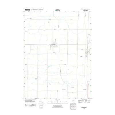
2012 Map of New Windsor
USGS Topo · Published 2012About this map
New Windsor and Alpha serve as the primary hubs in this section of western Illinois, connected by a network of rural roads that follow the township grid. The landscape is defined by the branching tributaries of Pope Cr and N Pope Cr, which carve through the agricultural landscape. Genealogists can identify several local burial sites, including New Windsor Cem, Calvary Cem, Alpha Cem, and Oxford Cem, which anchor the surrounding farmsteads. The settlement of Griffin sits in the northwest corner, while the Po in New Windsor marks the center of local commerce. Transportation history is visible in the alignment of Knoxville Trl and the descriptive Old Schoolhouse Ln, reflecting the early organization of rural schools and travel routes between these prairie communities.
Find a feature on this map
51 named features on this map. Tap any name to fly to it.
Don’t see what you’re looking for? This feature index may not catch every label — zoom into the map to look around manually.
Map Details
Editions of this 2012 New Windsor Map
This is the sole edition of this map. No revisions or reprints were ever made.
Other maps of this area

1912 · Milan
USGS Topo · 1:62,500

1923 · Alexis
USGS Topo · 1:62,500

1925 · Alexis
USGS Topo · 1:62,500

1937 · Orion
USGS Topo · 1:62,500

1944 · Milan
USGS Topo · 1:62,500

1947 · Woodhull
USGS Topo · 1:62,500

1953 · Woodhull
USGS Topo · 1:24,000

1953 · Viola
USGS Topo · 1:24,000
1953 · Andover
USGS Topo · 1:24,000
1953 · Matherville
USGS Topo · 1:24,000