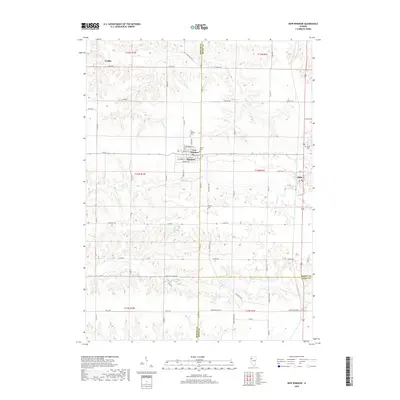
2018 Map of New Windsor
USGS Topo · Published 2018About this map
New Windsor and Alpha serve as the primary hubs in this section of Western Illinois, where the grid of rural roads meets the winding drainage of Pope Cr and N Pope Cr. The landscape is defined by the transition between the high, level agricultural plateaus and the more complex topography surrounding Parker Run in the north. This survey documents a significant concentration of local heritage sites, including the New Windsor Cem and Calvary Cem on the outskirts of the village, and the more isolated Oxford Cem to the south. Smaller locales such as Griffin appear as notable points of interest along the northern edge. The transportation network is a mix of established corridors like the Knoxville Trl and specialized routes such as Piper Hills Corral Rd, illustrating the intersection of modern logistics and the region's long-standing livestock and farming traditions.
Find a feature on this map
43 named features on this map. Tap any name to fly to it.
Don’t see what you’re looking for? This feature index may not catch every label — zoom into the map to look around manually.
Map Details
Editions of this 2018 New Windsor Map
This is the sole edition of this map. No revisions or reprints were ever made.
Other maps of this area

1912 · Milan
USGS Topo · 1:62,500

1923 · Alexis
USGS Topo · 1:62,500

1925 · Alexis
USGS Topo · 1:62,500

1937 · Orion
USGS Topo · 1:62,500

1944 · Milan
USGS Topo · 1:62,500

1947 · Woodhull
USGS Topo · 1:62,500

1953 · Woodhull
USGS Topo · 1:24,000

1953 · Viola
USGS Topo · 1:24,000
1953 · Andover
USGS Topo · 1:24,000
1953 · Matherville
USGS Topo · 1:24,000