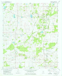
1980 Map of Newbern
USGS Topo · Published 1980About this map
The town of Newbern serves as the focal point of this western Alabama landscape, situated along the Southern RR railroad line near the border of Hale and Perry counties. The settlement pattern reflects a deeply rooted rural community, defined by numerous family and church-affiliated burial grounds such as Hatch Cem, McCreary Cem, and Tunstall Cem. Education and faith are central to the map's geography, evidenced by Sunshine Sch and a series of neighborhood churches including Mars Hill Ch and Mt Sinai Ch.
Find a feature on this map
33 named features on this map. Tap any name to fly to it.
Don’t see what you’re looking for? This feature index may not catch every label — zoom into the map to look around manually.
Map Details
Editions of this 1980 Newbern Map
This is the sole edition of this map. No revisions or reprints were ever made.
Other maps of this area

1953 · Montgomery
USGS Topo · 1:250,000

1956 · Montgomery
USGS Topo · 1:250,000

1957 · Montgomery
USGS Topo · 1:250,000

1968 · Uniontown West
USGS Topo · 1:24,000

1968 · Uniontown East
USGS Topo · 1:24,000

1968 · Gallion
USGS Topo · 1:24,000

1979 · Scott Station
USGS Topo · 1:24,000

1979 · Morgan Springs
USGS Topo · 1:24,000

1979 · Greensboro
USGS Topo · 1:24,000
1980 · Casemore
USGS Topo · 1:24,000