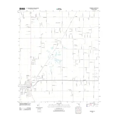
2012 Map of Newberry
USGS Topo · Published 2012About this map
Newberry and its surrounding rural communities are depicted in detail as they appeared in 2012, highlighting a transition from traditional agricultural landscapes to expanding residential grids. The intersection of local history and modern infrastructure is visible through the positioning of the Newberry Municipal Cem and the Jonesville Cem, which anchor the long-standing settlements of this Alachua County region. Small unincorporated communities like Wade, Forest Grove, and Cadillac define the northern reaches of the map, while Haile sits centrally among a network of local roads.
Find a feature on this map
66 named features on this map. Tap any name to fly to it.
Don’t see what you’re looking for? This feature index may not catch every label — zoom into the map to look around manually.
Map Details
Editions of this 2012 Newberry Map
This is the sole edition of this map. No revisions or reprints were ever made.
Other maps of this area

1890 · Arredondo
USGS Topo · 1:62,500

1892 · Arredondo
USGS Topo · 1:62,500

1894 · Arredondo
USGS Topo · 1:62,500

1954 · Gainesville
USGS Topo · 1:250,000

1958 · Gainesville
USGS Topo · 1:250,000

1959 · Gainesville
USGS Topo · 1:250,000

1962 · High Springs
USGS Topo · 1:24,000

1966 · Gainesville West
USGS Topo · 1:24,000

1966 · Arredondo
USGS Topo · 1:24,000
1966 · Alachua
USGS Topo · 1:24,000