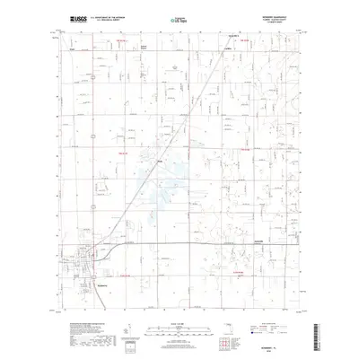
2018 Map of Newberry
USGS Topo · Published 2018About this map
Newberry and its surrounding communities in western Alachua County are shown in this topographic study, revealing the modern infrastructure and historic layout of this agricultural and residential region. The settlement pattern is anchored by small community centers like Jonesville, Haile, and Forest Grove, which are connected by a dense grid of rural roads such as NW 94th Ave and NW 62nd Ave. For genealogists and local historians, the map is an excellent resource for locating family burial sites, including the Newberry Municipal Cem, the Jonesville Cem, and the Forest Grove Cem. The landscape is characterized by its numerous small depressions and sinkholes, a classic feature of Florida karst topography, which dictates the placement of fields and homes. Local landmarks such as Sullivan Field and the outlying communities of Wade and Cadillac provide further context for the region's development.
Find a feature on this map
80 named features on this map. Tap any name to fly to it.
Don’t see what you’re looking for? This feature index may not catch every label — zoom into the map to look around manually.
Map Details
Editions of this 2018 Newberry Map
This is the sole edition of this map. No revisions or reprints were ever made.
Other maps of this area

1890 · Arredondo
USGS Topo · 1:62,500

1892 · Arredondo
USGS Topo · 1:62,500

1894 · Arredondo
USGS Topo · 1:62,500

1954 · Gainesville
USGS Topo · 1:250,000

1958 · Gainesville
USGS Topo · 1:250,000

1959 · Gainesville
USGS Topo · 1:250,000

1962 · High Springs
USGS Topo · 1:24,000

1966 · Gainesville West
USGS Topo · 1:24,000

1966 · Arredondo
USGS Topo · 1:24,000
1966 · Alachua
USGS Topo · 1:24,000