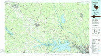
1986 Map of Newberry
USGS Topo · Published 1986About this map
Sumter National Forest anchors the northern landscape of this mid-1980s map, a region defined by its historic agricultural crossroads and significant river systems. The Broad River and Saluda River course through the terrain, with the latter feeding the expansive waters of Lake Murray. Local centers of education and industry are prominent, including Presbyterian College in the northwest and the textile-related settlements of Lydia Mills and Winnsboro Mills.
Find a feature on this map
182 named features on this map. Tap any name to fly to it.
Don’t see what you’re looking for? This feature index may not catch every label — zoom into the map to look around manually.
Map Details
Editions of this 1986 Newberry Map
2 editions found
Other maps of this area

1892 · Mc Cormick
USGS Topo · 1:125,000

1892 · Abbeville
USGS Topo · 1:125,000

1904 · Columbia
USGS Topo · 1:125,000

1908 · Kirksey
USGS Topo · 1:24,000

1912 · Mc Cormick
USGS Topo · 1:125,000

1935 · Killian
USGS Topo · 1:48,000

1937 · Killian
USGS Topo · 1:62,500

1941 · Spartanburg
USGS Topo · 1:250,000

1942 · Camden
USGS Topo · 1:125,000

1944 · Gilbert
USGS Topo · 1:62,500